
Gladstone ZIP Code Coverage
Official current sources reviewed for Gladstone list two ZIP codes: 64118 and 64119. They are postal service areas, not city boundaries or resident lists. The city ZIP map gives a local visual reference, the Missouri ZIP table identifies the city and county association, and USPS verifies an individual mailing address. Keep those sources separate when saving research notes. A result may use a postal city that differs from the municipal label on a map or a Clay County parcel.
| ZIP | Areas Covered | Post Office | Notes |
|---|---|---|---|
| 64118 | Gladstone postal area and addresses using the Gladstone preferred city label | Gladstone station, 7170 N Broadway Street, Kansas City, MO 64118-9998 | City map and Missouri table provide orientation; verify each address with USPS |
| 64119 | Northland and Kansas City preferred-postal-city geography, including some Gladstone-area addresses | Kansas City 64119 routing; the exact station depends on the address | Postal city can say Kansas City while local context says Gladstone |
No official current Gladstone ZIP table reviewed listed 64116. It is deliberately omitted here rather than presented as a serving code without a current authority. The number on an older paper record should be verified against its date and printed address, not silently converted to a current label.
Gladstone ZIP Code Map Guide
Gladstone’s street pattern explains why a postal check needs local context. The official map identifies N Holmes, N Oak Trafficway, N Antioch Road, N Broadway, N Jackson, N Chestnut, and numbered NE streets in the city grid. It also gives subdivision and street context when an older record uses a neighborhood name or legal description instead of a current number. Use the printed street form first. Put any standardized address form in a separate research field so the original evidence remains clear.
The City of Gladstone ZIP code map is the visual source for the local postal-area reference.

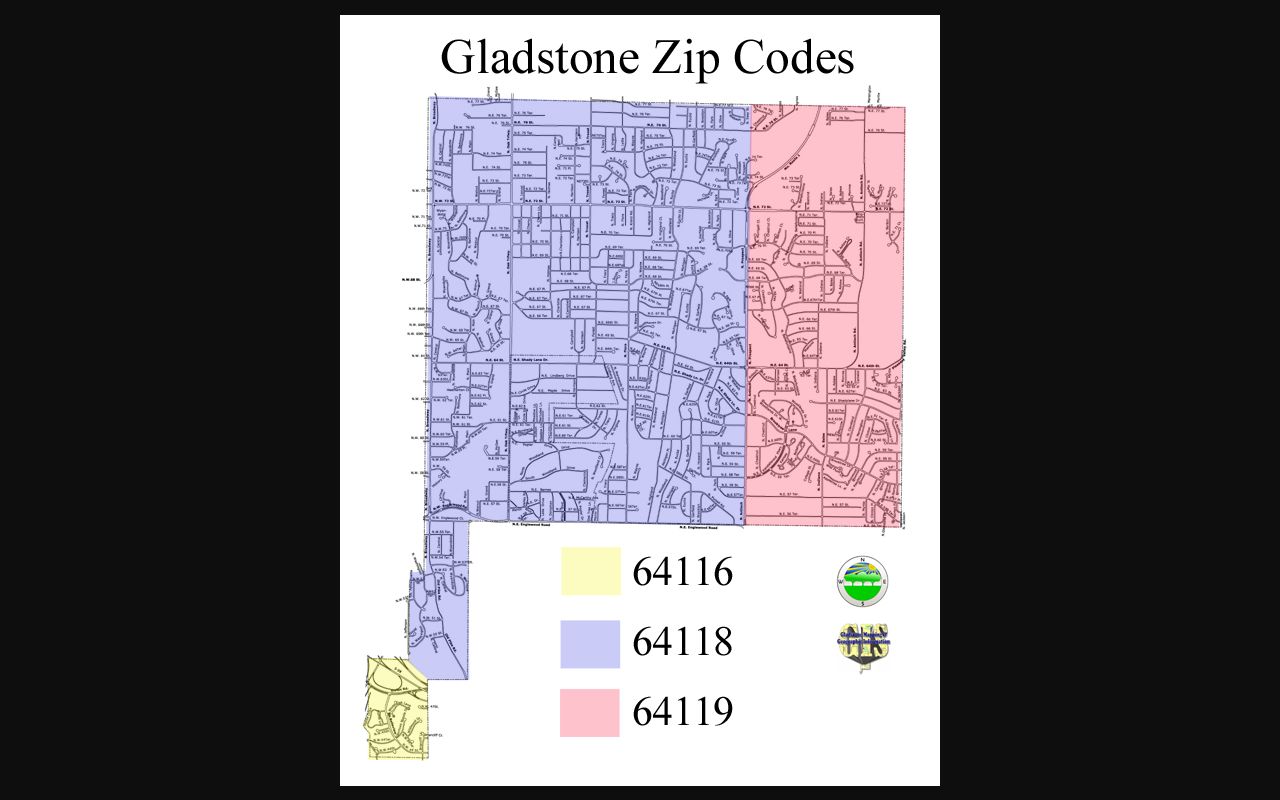
The map helps orient a street or subdivision, but it does not replace a USPS address result or the parcel boundary information held by Clay County.
County GIS is the mapping authority for parcel, centerline, city-boundary, subdivision, district, and address-range data. Its data-request form can seek centerlines with or without address ranges, roads, city boundaries, subdivisions, building footprints, and other layers. A specific road-assignment question belongs with County GIS or Gladstone Community Development or Public Works.
Gladstone ZIP Code Postal Mismatch
The local boundary issue is precise. The USPS archived preferred-city table routes 64118 through GLADSTONE, MO, while 64119 uses KANSAS CITY, MO. A Gladstone-area address can therefore carry a Kansas City preferred postal city. That wording affects mail and directory indexing, but it does not decide where the parcel sits, which government serves it, or whether a person lives there. Compare USPS, the city map, and Clay County parcel data before drawing a conclusion from one line of an address.
The USPS Gladstone station is listed at 7170 N Broadway in Kansas City, MO 64118-9998. That station address is not a rule for every 64118 or 64119 delivery point. The postal-city difference is especially important in historical directories, where Kansas City publications can include Gladstone addresses without claiming that each address was inside Kansas City.
Note: Preserve the city printed in the source, then record the USPS result and parcel context separately for later comparison.
Gladstone ZIP Code Search Fields
The official USPS ZIP Lookup is an address-verification tool, not a people search. It offers three documented paths. By Address is the best choice for one known street address. By City and State is a place-level inquiry, and Cities by ZIP begins with the ZIP itself. USPS warns that a lookup does not confirm a person or company at the displayed address. The AIS Viewer supplies monthly ZIP and address-quality reference reports and delivery types, but it is also not a resident record.
| USPS search field | Mode | Required | Use and format |
|---|---|---|---|
| Street address | By Address | Yes | Enter the address; company is optional and apartment information can be added. |
| City and state | By Address or By City and State | Required in the city-and-state mode | Use the printed postal city first when checking a historical record. |
| ZIP code | By Address or Cities by ZIP | Required for Cities by ZIP; optional in By Address | Use the five-digit ZIP to view postal-city associations. |
| Company | By Address | No | Optional field; a returned address is not proof of a current connection. |
Run the address exactly as known first. If the result does not match an older directory, try the historic postal city and street spelling, then use a map, plat, or legal description to determine whether the wording changed.
Finding Gladstone Residents by ZIP Code
A ZIP-wide resident list is not exposed through a single public button. The Clay Assessor selector accepts address, parcel ID, property ID, subdivision, and tax area, but no dedicated ZIP-wide mode was documented. The GIS viewer supports map geography and parcel browsing. The County Collector address search has an optional ZIP or Postal Code field. Missouri’s voter lookup requires a person’s exact identity details and county, not a ZIP filter. Use the postal area to narrow a record question, then follow the access route that fits the record type.
- Verify the street address and postal label with USPS, saving the result date and the exact form returned.
- Use the Clay Assessor or GIS map to locate the parcel by address, subdivision, parcel ID, or map position, rather than assuming the ZIP supplies a parcel list.
- Use the Collector address search when a tax-account question needs its optional ZIP or Postal Code field, then confirm the parcel identifiers.
- For a lawful defined voter-file request, ask the Clay County election authority about available ZIP, precinct, date, field, fee, and format limits under RSMo §115.157.
- Once the postal area is narrowed to a street, use the Gladstone by-street directory for the full address-record route.
The voter portal is a precise identity check, not a street roster. It requires registered first name, last name, date of birth, last four SSN, and county. Protected addresses and statutory release limits remain in force, and voter participation does not reveal ballot choices.
Gladstone ZIP Code Parcel Routes
Three county systems use different keys. The Assessor ties a parcel to its situs address, owner fields, mailing address, legal or map description, and assessment detail. GIS begins with map geometry and parcel identifiers. The Recorder’s deed index is alphabetical by name, not geographic, and cannot be searched by street address or location. The Collector can search by tax account, surname or business, or property address. A ZIP code may guide the first map or address check, but it does not replace those system-specific keys.
For a parcel question, start with the Clay County parcel search or the Clay County GIS viewer. The assessor result includes Prop ID, Parcel ID, owner, situs, and map description. A selected parcel can lead to legal description and sale-reference detail. If an older deed must be examined, use the legal description or party name with the Recorder’s iCounty access or its public terminal.
Do not treat the owner mailing field as a current residence statement. It can differ from the situs address, and a parcel record is evidence about assessed property, not a list of all people connected with the location.
Gladstone ZIP Code Terms
Postal words describe delivery organization. They are useful only when their limits are clear. The following definitions keep a Gladstone ZIP code search from being confused with a city-boundary, parcel, or resident-record search.
- ZIP code
- A postal routing code used to organize mail delivery. It does not set a municipal border.
- ZIP+4
- An added four-digit delivery detail used with a five-digit ZIP to narrow mail routing for an address or delivery point.
- PO-box ZIP
- A ZIP used for post-office boxes, which may not represent physical street delivery coverage.
- Unique ZIP
- A ZIP assigned for a particular organization or delivery purpose; no such Gladstone ZIP was documented in the reviewed sources.
- Carrier route
- A delivery route grouping used by postal operations; it is not a parcel boundary or household list.
Gladstone’s documented issue is not a confirmed unique or box-only ZIP. It is the difference between a Gladstone 64118 preferred-city label and a Kansas City 64119 preferred-city label. USPS is the final check for mailing, while the county parcel chain answers parcel geography.
Gladstone ZIP Code Historical Labels
Older research needs more than the current postal result. MGC Kansas City directories that include Gladstone, Kansas City Public Library directories, phone books, and the 1986 Liberty directory can preserve the postal city used at the time. A 1965 Kansas City volume that includes Gladstone shows a regional publishing decision, not a municipal-border ruling. Compare the printed street and city with the city map, legal description, subdivision, and current USPS result before normalizing the record.
Gladstone incorporated in 1952, but postal designations do not mark incorporation. A neighborhood or rural-edge description in an older entry may be the better lead. If a street number looks wrong, search the lot, block, subdivision, or plat rather than assuming the current ZIP or street form existed when the directory was printed.
Note: Historical directories and phone books can locate a date-bound postal label, but they are not a current occupancy source.
Gladstone ZIP Code Access Options
Online access includes the city ZIP and street maps, the Missouri ZIP table, USPS Lookup and AIS, and the County Assessor, GIS, and Collector tools. For a map-layer or address-range question, call or visit County GIS, Gladstone Community Development or Public Works, or the USPS station as appropriate. The County GIS data-request form seeks official layers. A Sunshine request can seek a defined public address-range or district record when an online display does not answer the question.
For historical work, consult MGC, Kansas City Public Library, Clay County Archives, and SHSMO. Do not assume that school attendance, utilities, delivery details, or private customer records are public just because an address has a ZIP code. Confirm a custodian’s fee, available format, and lawful scope before submitting a mail, phone, in-person, or records request.